The Day Honeymoon Island Started Breaking Apart, and the New Island It Became
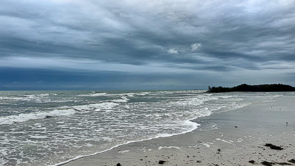
On April 3, 2024, I took a walk on Honeymoon Island, the way I have walked it twice a week for years. It had been raining hard most of that week, the kind of stretched-out spring rain that softens everything. I went out to the north end of the island, where I usually go, and somewhere along the way the beach changed.
A foot of water was moving across the middle of the island. From one side of it to the other. Where there had always been sand, there was a low channel, shallow enough to walk across in shoes, the gulf on one side feeding into the bay on the other. I had walked the same beach a hundred times. The water had never been there before.
I took pictures with my phone. I crossed it. I came back the same way, and on the walk to the car the rain caught up with me and I stopped to photograph the waves before I got soaked. I did not know yet what I was looking at. I thought maybe it was a low spot the rain had pooled, or a temporary cut from the week’s weather, the kind of thing that would settle back in a few days. People on Facebook and Instagram had started posting about it. Word was getting around.
What I did not know that day was that the island had started breaking in half. The April channel held through the spring and summer. Then Hurricane Helene came in September. Then Milton came in October. And by the time the back-to-back storms were finished with the Florida Gulf Coast, the foot-deep channel I had walked across in April was a working pass, with the north end of Honeymoon Island separated into what is now, in the language of the people who walk and work on this island, Oystercatcher Key.
This is the story of how that happened, what it looks like now, and what it means for a place that I have loved as long as I have lived in Dunedin.
An Island That Has Done This Before
The first thing worth knowing is that Honeymoon Island has been here before. Not the modern park exactly, but the geological story of an island being split apart by a hurricane.
Honeymoon Island and Caladesi Island, just to the south, were once a single barrier island called Hog Island. The 1921 hurricane cut a pass straight through it and made the one island into two. The new water between them got the name Hurricane Pass, for the obvious reason. That is the gap that today separates Honeymoon Island from Caladesi.
In other words, a hundred years before the 2024 storms, this same stretch of coast watched a hurricane do the same thing. The island has always been at the mercy of the Gulf, because that is what barrier islands are. They are sand and dunes piled up by water and held in place, for a while, by vegetation, until a strong enough storm rearranges everything. The land here was never permanent. It was always borrowed.
That history matters because it puts the 2024 break in context. What happened last year was not an aberration. It was the same thing that happened in 1921, on the same chain of barrier islands, by the same mechanism. The only thing that has changed is that there is now a state park on top of it, and a million visitors a year, and a lot more people watching closely.
April 3, 2024
I have walked Honeymoon Island twice a week for years. Mostly the trail out to the north point, sometimes the south end, almost always with a camera in some form. I know the island the way you know a stretch of road you drive every day, which means you notice when something is different even when you cannot say why.
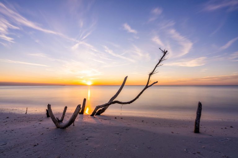
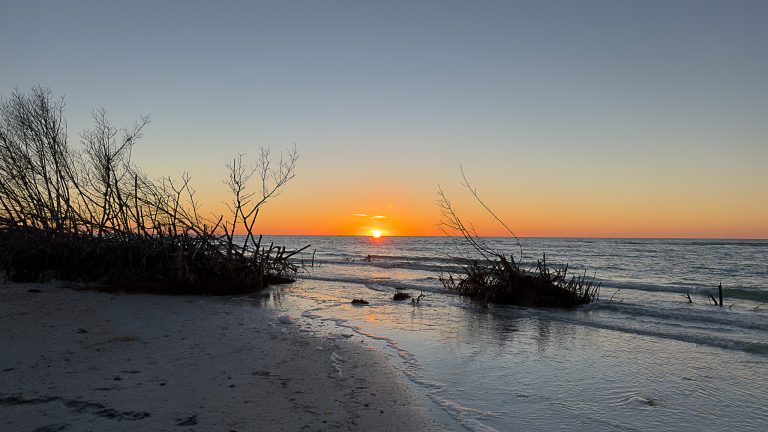
On April 3, the difference was the water across the sand. The break was maybe a hundred feet wide, give or take, and the channel was shallow, about a foot at its deepest where I crossed. It was wadeable. People were walking it. The water moved slowly. It did not feel dramatic. It felt strange, the way it feels when you find a new shortcut in a neighborhood you thought you knew completely.
But it stayed. I went back that week, and the next week, and the channel was still there. The rain that had been blamed for it slowed down, and the water stayed anyway. By summer it was clear that something had changed in the island’s shape. The break was the early version of what would become permanent, but in April nobody was calling it that yet. People were still hoping the sand would close it back up.
Sand does close gaps like that, sometimes. Tides move material around. A calm few months can fill in what an active few months opened up. The island was doing what islands do, and the question was just how the year was going to push it.
The year, it turned out, pushed it hard.
What Helene and Milton Did
Hurricane Helene came up the Gulf in late September 2024. It made landfall in the Big Bend, well north of Pinellas County, but Helene was a massive storm, and it pushed a wall of Gulf water far ahead of it. The surge along the Pinellas coast was severe. Honeymoon Island took the full brunt of it.
Two weeks later, before anyone had even started cleaning up, Hurricane Milton came across the state and made landfall near Siesta Key, much closer to home. Milton hit Honeymoon Island directly with hurricane-force winds and another surge.
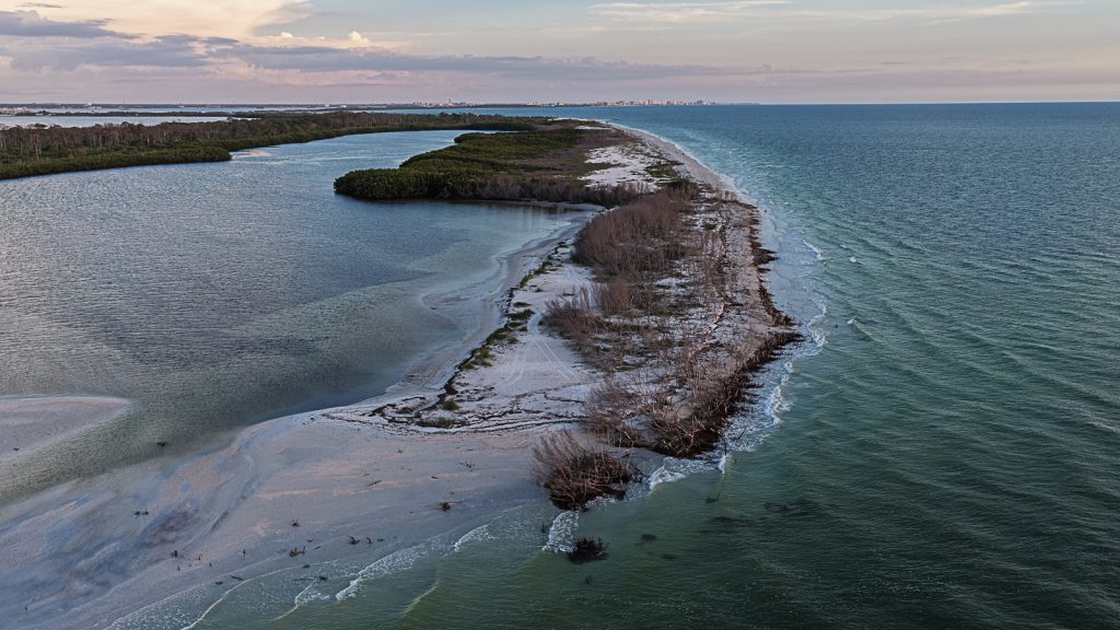
The Friends of Island Parks, the support group for the state park, later said it was the greatest damage Honeymoon Island had suffered since the 1929 hurricane. Nearly a century of accumulated dune and beach were rearranged in a matter of weeks. Buildings were damaged. The Causeway flooded. Parts of the island disappeared. And the small break I had walked across in April, that had widened slowly through the summer, was finished off. It became a real pass. The north end of the island became its own piece of land, no longer reachable on foot from the rest of the park.
For weeks the park was closed. The Bluegrass Festival that had been scheduled for December was canceled because of the damage. When the park began to reopen, it did so in pieces, with the south end first and the north sections still under repair.
The state’s response has been substantial. The Florida Park Service contracted Gator Dredging of Clearwater to move 168,000 cubic yards of sand from Hurricane Pass back onto the island, used to restore the beaches and rebuild the dunes that the storms had taken. By March 2025, the dune restoration work was complete and 30,000 sea oats had been planted to hold the new sand in place. The park is open again now, though not exactly the park it was a year and a half ago.
What the dredging and replanting did not do, and could not do, was put the north end back. The pass that the storms cut between the main island and what is now its own small island has stayed. That part of the change is permanent, or at least permanent for the foreseeable future.
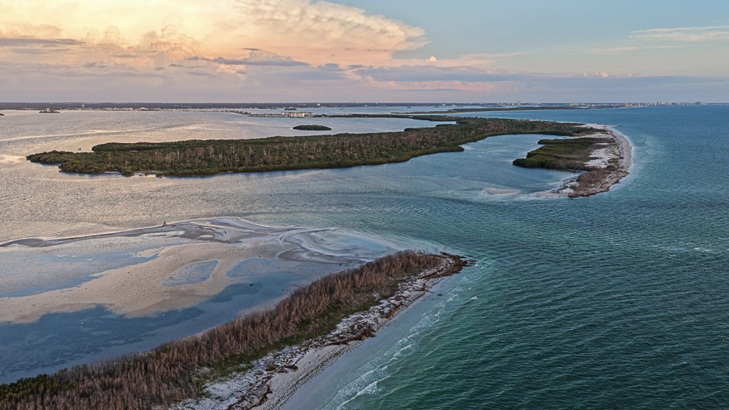
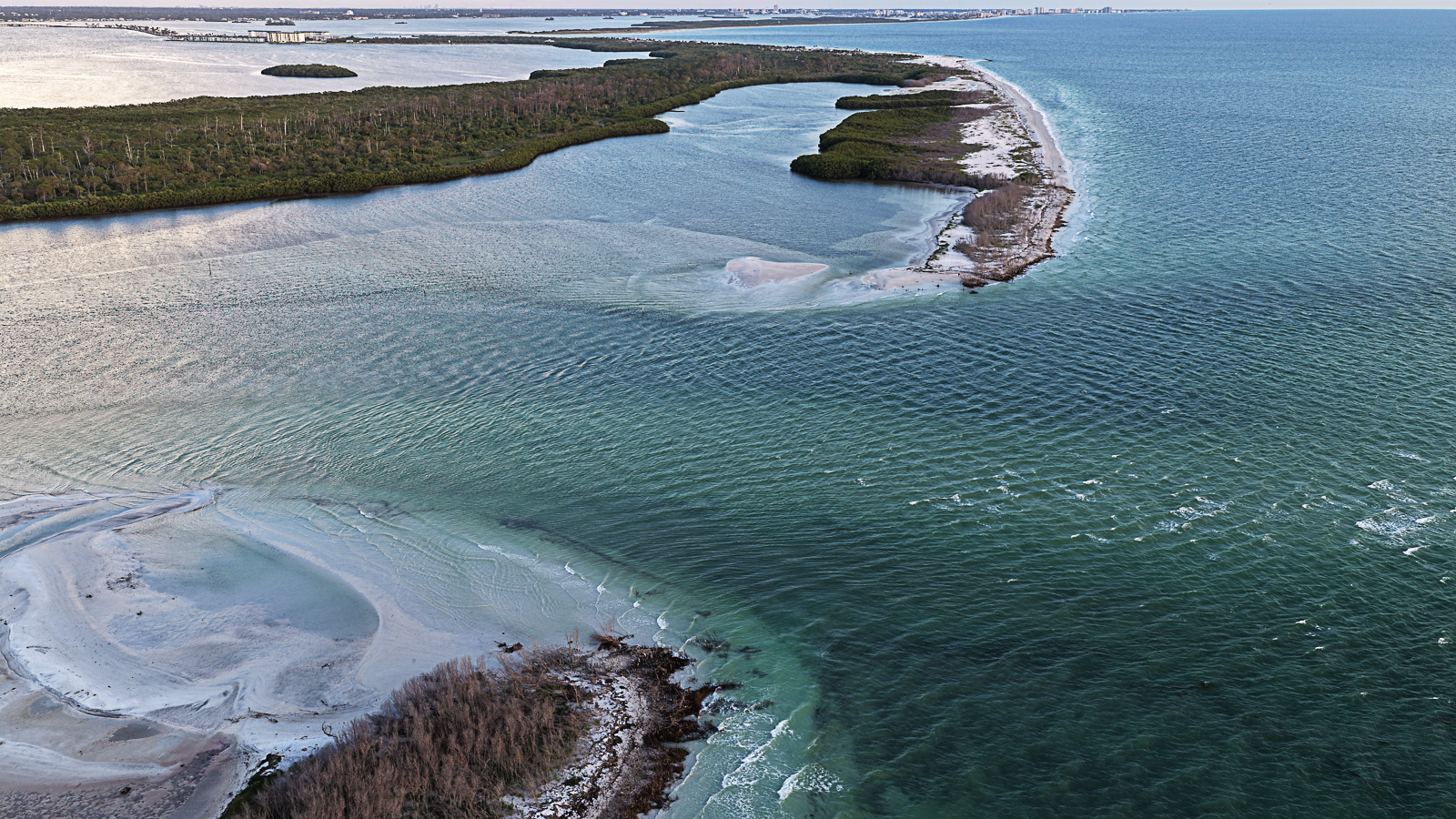
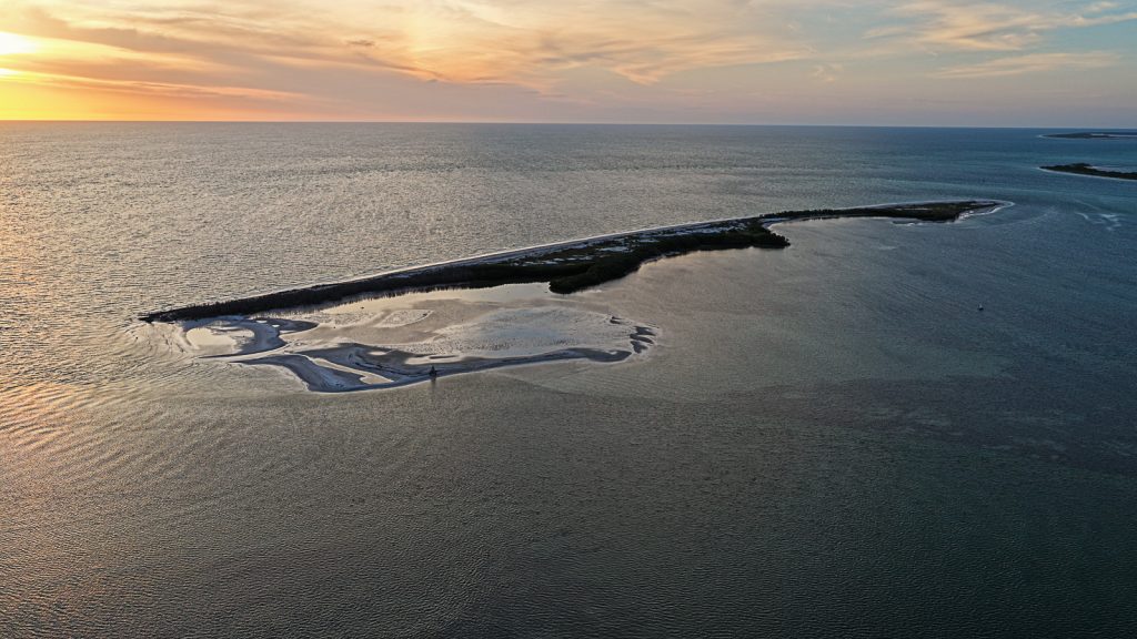
Oystercatcher Key
The new island does not have an official name. I have looked. The state has not designated it. No formal mapping authority has christened it. As far as the agencies are concerned, it is simply a portion of Honeymoon Island State Park that is currently separated from the main body by a tidal channel.
But the people who walk the beaches and work in the park have started calling it Oystercatcher Key. A few volunteers I have talked to use the name. Locals on social media use it. It has not been declared, it has just emerged, which is how a lot of names actually work in places where the official record is one step behind the people who live somewhere.
The name comes from the American oystercatcher, one of the shorebirds that nests on Honeymoon Island. The oystercatcher is a striking bird with a long red-orange bill, mostly dark above and white below, and Honeymoon Island is one of the more important nesting sites for the species on this part of the Florida coast. Calling the new island Oystercatcher Key is a quiet act of attention to the birds that use it, and to the broader ecological identity of the place. It is a better name than any committee would have given it.
Whether the name sticks long-term, whether the state ever recognizes it formally, or whether the channel closes again over years of tidal deposition and the question becomes moot, I do not know. For now, that is what it is being called, and the name is doing its work.
What I Saw Tonight
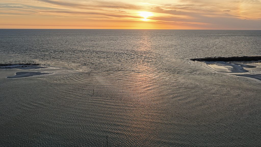
I went out by boat earlier this evening, with my drone. I want to be clear about that, because it matters.
Drones are not permitted in or over Honeymoon Island State Park. That is a Florida State Parks rule and it is the right rule. State parks are protected for reasons that include the nesting birds, the sea turtles, the gopher tortoises, and the people who go there to be away from the noise of motors. So when I want aerial photographs of the island, I take my boat out into the Gulf, anchor offshore, and fly the drone from there, staying over the water rather than over the protected land. Tonight is the same way I have always done it.
What you see from above, from the Gulf side, is the new shape of the island. The pass between Honeymoon and the new key is visible and active, with water moving through it on every tide. The north end of the former Honeymoon, now Oystercatcher Key, is its own small island, narrower than it used to be, with the marks of recent storms still on it. The sand is whiter where it has been recently rearranged. The dune line is broken. There are stretches where the vegetation has not come back yet, and you can see all the way across the island in places where you used to walk through scrub. It looks both new and old. New, because the configuration is recent. Old, because this is how the place looked, more or less, in some past century when no one was here to photograph it.
The birds are using it. Oystercatchers, plovers, terns, skimmers, the regular cast. A new island, especially one that humans cannot easily walk onto, is genuinely useful to nesting shorebirds. Whatever this break has done to the human experience of Honeymoon Island, it has probably been a gift to the wildlife. There is something to think about in that.
What It Means
I have lived in Dunedin since 2013, and Honeymoon Island is one of my favorite places on earth. I walk it twice a week. I have photographed it in every kind of light. The day in April when I first noticed the water across the sand was one of the most surprising moments I have had in years of walking that island, and I did not yet know what I was watching. Now I do.
What it means, I think, is that we are residents of a place that is still being shaped. The barrier islands along the Gulf are not finished objects. They are works in progress, made and remade by storms, settling and reforming over the human-scale time we get to be here. We tend to talk about places like Honeymoon Island as if they are permanent, fixed, the same today as yesterday, the same next year as last. They are not. The 1921 hurricane reminded the previous generation of that. The 2024 storms have reminded ours.
I will keep walking the island. The trail out to the point is shorter now, because the point is on a different island, but the walk is still the walk. I will keep watching the channel. I will keep flying the drone from my boat offshore to see how the new shape of the place is settling. And I will keep calling it Oystercatcher Key, because the people who walk this island every day have decided that is its name, and they are usually the ones who get this kind of thing right.
If you have not been out since the storms, go. The park is open. The beaches have been restored. The dunes are coming back. The view from the north end is different now, because the north end is not where it used to be, but it is still one of the best places in this state to stand at the edge of the Gulf and watch the day move. And if you stand there long enough, look across the new channel. That is Oystercatcher Key. It used to be where you were standing.
For more on Honeymoon Island and how it fits into the life of Dunedin, see my earlier piece Dunedin Florida Parks Trails and Waterfront on this site, and my LinkedIn article on what Honeymoon Island reveals about what Florida almost lost. For the practical resident’s perspective on the island, see my piece for MiddletonTampaBay.com.
About the author. I am Mark Middleton. I have lived in Dunedin since 2013, walk Honeymoon Island twice a week, and was on the island on April 3, 2024 when the channel first opened. I am a photographer in my personal life, and I always fly drones from my boat offshore rather than over the protected state park, where drones are not permitted. I am also a Realtor with Compass, leading Middleton Tampa Bay, though my work on this site is about Dunedin itself rather than about real estate.